|
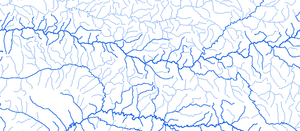
Bassin du Chari
|
||||
|
|
||||
|
RAPPEL : Le téléchargement de données est libre moyennant un enregistrement sur ce site et l'édition et le renvoi de la déclaration de l'utilisateur signée.
|
||||
|
|
||||
|
Le Chari |
 |
|||
|
Baibokoum 15°40'01"E 7°45'01"N |
 |
 |
 |
 |
|
Balimba
18°21'01"E 09°08'01"N
|
|
|
|
|
|
Bamingui 20°11'01"E
7°34'01"N
|
|
|
|
|
|
Bangoran 20°21'01"E
8°05'01"N
|
|
|
|
|
|
Batangafo 18°17'01"E
7°18'01"N
|
|
|
|
|
|
Bea 17°05'01"E 6°29'01"N |
|
|
|
|
|
Bologo
15°48'01"E 9°07'01"N
|
|
|
|
|
|
Bongor 15°25'01"E
10°16'01"N
|
|
|
|
|
|
Bossangoa 17°27'01"E
6°28'01"N
|
|
|
|
|
|
Bouca 18°16'01"E
6°30'01"N
|
|
|
|
|
|
Bousso 16°43'01"E
10°31'01"N
|
|
|
|
|
|
Bozoum
16°2101'"E 6°21'01"N
|
|
|
|
|
|
Doba 16°51'01"E
8°39'01"N
|
|
|
|
|
|
Doba Cotonfran 16°50'01"E
8°39'01"N
|
|
|
|
|
|
Gore 16°37'01"E
7°57'01"N
|
|
|
|
|
|
Guelengdeng 15°33'01"E
10°55'01"N
|
|
|
|
|
|
Hellibongo 18°19'01"E
9°15'01"N
|
|
|
|
|
|
Kaga Bandoro 19°11'00"E
7°00'00"N
|
|
|
|
|
|
Katoa 15°05'00"E
10°50'00"N
|
|
|
|
|
|
Koukourou 20°01'00"E
7°12'00"N
|
|
|
|
|
|
Kyabe
18°57'00"E 9°24'00"N
|
|
|
|
|
|
Lai Mission 16°18'00"E
9°24'00"N
|
|
|
|
|
|
Logone-Gana 15°09'00"E
11°33'00"N
|
|
|
|
|
|
Mailao
15°17'00"E 11°36'00"N
|
|
|
|
|
|
Manda 18°12'00"E
9°11'00"N
|
|
|
|
|
|
Markounda 16°58'00"E
7°38'00"N
|
|
|
|
|
|
M'Bere 15°27'00"E
7°26'00"N
|
|
|
|
|
|
Moissala 17°46'00"E
8°20'00"N
|
|
|
|
|
|
Moundou Pont 16°05'00"E 8°33'36"N |
|
|
|
|
|
Ndjamena 15°02'00"E
12°07'00"N
|
|
|
|
|
|
Ouli Bangala 15°50'00"E
7°50'00"N
|
|
|
|
|
|
Sahr 18°25'00"E 9°09'00"N |
|
|
|
|
|
Tchoa 16°05'00"E
9°20'00"N
|
|
|
|
|
|
|
||||