|
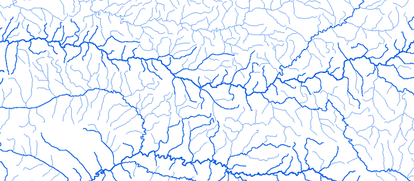
Bassin du Nyong
|
||||
|
|
||||
|
RAPPEL : Le téléchargement de données est libre moyennant un enregistrement sur ce site et l'édition et le renvoi de la déclaration de l'utilisateur signée.
|
||||
|
|
||||
|
Le Nyong |
 |
|||
|
Akonolinga 03°47'01"E 12°15'01"N |
 |
 |
 |
 |
|
Dehane 03°34'01"E 10°07'01"N |
|
|
|
|
|
Eséka 03°35'21"E 10°41'21"N |
|
|
|
|
|
Lolodorf 03°14'01"E 10°44'01"N |
|
|
|
|
|
M'Balmayo 03°31'01"E 11°30'01"N |
|
|
|
|
|