|
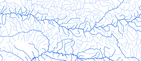
Bassin du Senegal
|
||||
|
|
||||
|
RAPPEL : Le téléchargement de données est libre moyennant un enregistrement sur ce site et l'édition et le renvoi de la déclaration de l'utilisateur signée.
|
||||
|
|
||||
|
Le Senegal |
 |
|||
|
Ambidedi 11°47'00"W 14°35'01"N |
 |
 |
 |
 |
|
Bafing Makana 10°16'00"W 12°33'01"N |
|
|
|
|
|
Bakel 12°27'00"W 14°54'01"N |
|
|
|
|
|
Bebele 11°49'00"W 11°01'01"N |
|
|
|
|
|
Daka Saidou 10°37'00"W 11°57'01"N |
|
|
|
|
|
Dibia 10°48'00"W 13°14'01"N |
|
|
|
|
|
Fadougou 11°23'00"W 12°31'01"N |
|
|
|
|
|
Galougo 11°08'00"W 13°50'01"N |
|
|
|
|
|
Gourbassy 11°38'00"W 13°24'01"N |
|
|
|
|
|
Kayes 11°27'00"W 14°27'01"N |
|
|
|
|
|
Kidira Uhea 12°13'00"W 14°27'01"N |
|
|
|
|
|
Oualia 10°23'00"W 13°36'01"N |
|
|
|
|
|
Siramakana (Balenda) |
|
|
|
|
|
Sokotoro 11°45'00"W 10°39'01"N |
|
|
|
|
|
Soukoutali 10°25'00"W 13°12'01"N |
|
|
|
|
|
Toukoto 10°00'00"W 13°27'01"N |
|
|
|
|
|
Trokoto 11°41'00"W 11°15'01"N |
|
|
|
|
|