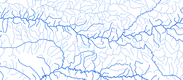
Bassin de la Volta

RAPPEL : Le téléchargement de données est libre moyennant un enregistrement sur ce site et l'édition et le renvoi de la déclaration de l'utilisateur signée.

La Volta

Hydrographic network

Atchangbade 01°07'01"E 09°28'01"N

Outline
Geology
Holdridge Vegetation
WaterHoldingCapacity

Bamboi 2°02'00"W 08°09'01"N

Outline
Geology
Holdridge Vegetation
WaterHoldingCapacity

Barkoissi 00°19'01"E 10°32'01"N

Outline
Geology
Holdridge Vegetation
WaterHoldingCapacity

Batie 2°54'21"W 09°55'43"N

Outline
Geology
Holdridge Vegetation
WaterHoldingCapacity

Bongoulou 2 00°40'55"E 09°00'55"N

Outline
Geology
Holdridge Vegetation
WaterHoldingCapacity

Borgou 00°34'01"E 10°45'01"N

Outline
Geology
Holdridge Vegetation
WaterHoldingCapacity

Boromo 2°55'00"W 11°47'01"N

Outline
Geology
Holdridge Vegetation
WaterHoldingCapacity

Dapola 2°55'00"W 10°34'01"N

Outline
Geology
Holdridge Vegetation
WaterHoldingCapacity

Diebougou 3°10'00"W 10°56'50"N

Outline
Geology
Holdridge Vegetation
WaterHoldingCapacity

Dzobegan 00°40'45"E 07°14'30"N

Outline
Geology
Holdridge Vegetation
WaterHoldingCapacity

Koumangou 00°27'01"E 10°12'01"N

Outline
Geology
Holdridge Vegetation
WaterHoldingCapacity

Kpesside 00°57'01"E 09°37'01"N

Outline
Geology
Holdridge Vegetation
WaterHoldingCapacity

Lama Kara 1 01°11'01"E 09°32'01"N

Outline
Geology
Holdridge Vegetation
WaterHoldingCapacity

Mandouri 00°51'20"E 10°50'30"N

Outline
Geology
Holdridge Vegetation
WaterHoldingCapacity

Mane 1°20'00"W 12°59'01"N

Outline
Geology
Holdridge Vegetation
WaterHoldingCapacity

Naboulgou 1 00°49'01"E 10°09'01"N

Outline
Geology
Holdridge Vegetation
WaterHoldingCapacity

Naboulgou 2 00°46'01"E 10°07'01"N

Outline
Geology
Holdridge Vegetation
WaterHoldingCapacity

Nagbeni 00°24'01"E 10°36'01"N

Outline
Geology
Holdridge Vegetation
WaterHoldingCapacity

Nasia 0°48'00"W 10°09'01"N

Outline
Geology
Holdridge Vegetation
WaterHoldingCapacity

Nawuni 1°05'00"W 09°42'01"N

Outline
Geology
Holdridge Vegetation
WaterHoldingCapacity

Niagho 0°45'00"W 11°46'10"N

Outline
Geology
Holdridge Vegetation
WaterHoldingCapacity

Nobere 1°11'00"W 11°26'10"N

Outline
Geology
Holdridge Vegetation
WaterHoldingCapacity

Nwokuy 3°33'00"W 12°31'40"N

Outline
Geology
Holdridge Vegetation
WaterHoldingCapacity

Paio 00°43'01"E 10°13'01"N

Outline
Geology
Holdridge Vegetation
WaterHoldingCapacity

Pont de Leri Nord 3°26'24"W 12°45'01"N

Outline
Geology
Holdridge Vegetation
WaterHoldingCapacity

Porga 00°58'01"E 11°03'01"N

Outline
Geology
Holdridge Vegetation
WaterHoldingCapacity

Pont dOuessa 11°01'10"W 2°49'00"N

Outline
Geology
Holdridge Vegetation
WaterHoldingCapacity

Pwalagu 0°51'00"W 10°35'01"N

Outline
Geology
Holdridge Vegetation
WaterHoldingCapacity

Sabora 00°19'01"E 09°36'01"N

Outline
Geology
Holdridge Vegetation
WaterHoldingCapacity

Samandeni 4°28'00"W 11°28'01"N

Outline
Geology
Holdridge Vegetation
WaterHoldingCapacity

Sansanne Mango 00°28'01"E 10°18'01"N

Outline
Geology
Holdridge Vegetation
WaterHoldingCapacity

Senchi Halcrow 00°05'36"E 06°12'01"N

Outline
Geology
Holdridge Vegetation
WaterHoldingCapacity

Tiele 01°12'01"E 10°43'01"N

Outline
Geology
Holdridge Vegetation
WaterHoldingCapacity

Titira 01°06'30"E 10°00'01"N

Outline
Geology
Holdridge Vegetation
WaterHoldingCapacity

Tourouba 3°43'00"W 12°22'10"N

Outline
Geology
Holdridge Vegetation
WaterHoldingCapacity

Wayen 1°05'00"W 12°23'01"N

Outline
Geology
Holdridge Vegetation
WaterHoldingCapacity

Yakala 0°30'00"W 11°24'01"N

Outline
Geology
Holdridge Vegetation
WaterHoldingCapacity

Yapei 1°10'00"W 09°09'01"N

Outline
Geology
Holdridge Vegetation
WaterHoldingCapacity

Yilou 1°33'00"W 13°00'01"N

Outline
Geology
Holdridge Vegetation
WaterHoldingCapacity
Fermer cette page Imprimer cette page
© UMR HydroSciences Montpellier