|
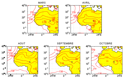
The geopotential at 1000 hPa The geopotential is a pressure field whose meridian variations define a pressure gradient, oriented from high pressure zones (anticyclone) towards low pressure zones (depression). The higher the geopotential altitude is, the more the observation is done in a high pressure zone. A low geopotential located between high gepotentials corresponds to a convergence zone. As it happens in West Africa, a geopotential at a low altitude identifies the place of the ITCZ. The anticyclones are subsidence zones where the water vapor is low. The 1000hPa level corresponds to the surface conditions (from some meters to some tenth of meters high). The following maps illustrate the altitude variations of the geopotential.
In March-April, the Azores anticyclone is off the North African coast, over the Atlantic Ocean. Its major characteristic is a geopotential height included between 130 and 170 m. In August, the St Helens anticyclone moves northwards up to the Gulf of Guinea, with a geopotential height to 130 m. Generally, the Azores anticyclone is reinforces with an increase of the geopotential (150 to 190 m). The seasonnal evolution is particularly well visible from August to October: |
 |
|
Mean monthly variations of the geopotential at 1000 hPa over Africa during the period 1968-1998
|
 |
 Close this window
 To print this page