|
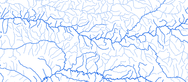
Bassin du Bandama
|
||||
|
|
||||
|
RAPPEL : Le téléchargement de données est libre moyennant un enregistrement sur ce site et l'édition et le renvoi de la déclaration de l'utilisateur signée.
|
||||
|
|
||||
|
Le Bandama |
 |
|||
 |
 |
 |
 |
|
|
Bafécao 4°54'00"W 06°01'10"N |
|
|
|
|
|
Bocanda 4°31'12"W 7°02'39"N |
|
|
|
|
|
Bouaflé 5°45'02" W 6°58'51"N |
|
|
|
|
|
Dimbokro 4°42'36"W 6°38'91"N |
|
|
|
|
|
Farandougou 6°40'58"W 9°12'11"N |
|
|
|
|
|
Fétékro 4°41'15"W 7°48'38"N |
|
|
|
|
|
Kimoukro 5°18'19"W 6°30'20"N |
|
|
|
|
|
Mankono 6°18'21"W8°07'30"N |
|
|
|
|
|
Marabadiassa 5°25'30"W 8°06'20"N |
|
|
|
|
|
Mbahiakro 4°21'20"W 7°26'45"N |
|
|
|
|
|
Nzienoa 4°48'45"W 5°59'47"N |
|
|
|
|
|
Route Beoumi-Seguela-Kongasso 6°15'15"W 7°49'45"N |
|
|
|
|
|
Seguela 6°29'15"W 8°01'20"N |
|
|
|
|
|
Tiassale 4°49'04"W 5°53'41"N |
|
|
|
|
|
Tiebissou 8°13'00"W 7°11'41"N |
|
|
|
|
|
Tortya Amont 5°31'40"W8°45'50"N |
|
|
|
|
|
|
||||
Bada 5°29'50"W 08°06'25"N