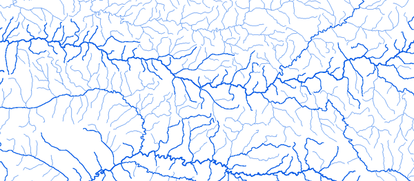
Bassin du Congo

RAPPEL : Le téléchargement de données est libre moyennant un enregistrement sur ce site et l'édition et le renvoi de la déclaration de l'utilisateur signée.

Le Congo

Hydrographic network

Alindao 21°12'00"E 05°03'01"N

Outline
Geology
Holdridge Vegetation
WaterHoldingCapacity

Aval barrage 15°13'01"E 4°18'00"S

Outline
Geology
Holdridge Vegetation
WaterHoldingCapacity

Bambari 20°40'01"E 5°46'01"N

Outline
Geology
Holdridge Vegetation
WaterHoldingCapacity

Bangassou 22°49'01"E 4°43'01"N

Outline
Geology
Holdridge Vegetation
WaterHoldingCapacity

Bangui(Mpoko) 18°29'00"E 4°22'01"N

Outline
Geology
Holdridge Vegetation
WaterHoldingCapacity

Bangui(Oubangui) 18°35'01"E 4°22'01"N

Outline
Geology
Holdridge Vegetation
WaterHoldingCapacity

Batouri 14°19'01"E 4°25'01"N

Outline
Geology
Holdridge Vegetation
WaterHoldingCapacity

Bewiti 15°11'01"E 05°49'01"N

Outline
Geology
Holdridge Vegetation
WaterHoldingCapacity

Biwala 14°57'01"E 3°09'01"N

Outline
Geology
Holdridge Vegetation
WaterHoldingCapacity

Boali - I.C.O.T

18°02'01"E 04°53'01"N

Outline
Geology
Holdridge Vegetation
WaterHoldingCapacity

Boali Poste 18°07'01"E 04°49'01"N

Outline
Geology
Holdridge Vegetation
WaterHoldingCapacity

Bombe 18°14'01"E 04°06'01"N

Outline
Geology
Holdridge Vegetation
WaterHoldingCapacity

Bossele (Km 105)

18°52'01"E 05°10'01"N

Outline
Geology
Holdridge Vegetation
WaterHoldingCapacity

Bossele-Bali 18°28'01"E 04°32'01"N

Outline
Geology
Holdridge Vegetation
WaterHoldingCapacity

Botouali 17°20'91"E 00°33'01"N

Outline
Geology
Holdridge Vegetation
WaterHoldingCapacity

Brazzaville 15°19'01"E 4°16'00"S

Outline
Geology
Holdridge Vegetation
WaterHoldingCapacity

Bria 22°00'01"E 06°32'01"N

Outline
Geology
Holdridge Vegetation
WaterHoldingCapacity

Bwembé 15°37'51"E 2°59'30"S

Outline
Geology
Holdridge Vegetation
WaterHoldingCapacity

Carnot 15°52'01"E 04°56'01"N

Outline
Geology
Holdridge Vegetation
WaterHoldingCapacity

Dembia 24°29'01"E 05°06'01"N

Outline
Geology
Holdridge Vegetation
WaterHoldingCapacity

Doume 13°27'01"E 4°14'01"N

Outline
Geology
Holdridge Vegetation
WaterHoldingCapacity

Etoumbi 14°57'01"E 00°00'01"N

Outline
Geology
Holdridge Vegetation
WaterHoldingCapacity

Gamboma 15°51'01"E 1°54'00"S

Outline
Geology
Holdridge Vegetation
WaterHoldingCapacity

Goma Tsé Tsé 15°07'01"E 4°13'01"S

Outline
Geology
Holdridge Vegetation
WaterHoldingCapacity

Kedingue-Yawa 17°04'01"E 04°21'01"N

Outline
Geology
Holdridge Vegetation
WaterHoldingCapacity

Kembe 21°55'01"E 04°36'01"N

Outline
Geology
Holdridge Vegetation
WaterHoldingCapacity

Kerre 05°21'01"E 01°45'01"N

Outline
Geology
Holdridge Vegetation
WaterHoldingCapacity

Kibossi 15°00'01"E 4°13'01"S

Outline
Geology
Holdridge Vegetation
WaterHoldingCapacity

Kimpanzou Amont 14°56'01"E 4°36'00"S

Outline
Geology
Holdridge Vegetation
WaterHoldingCapacity

Linnegue 15°56'01"E 00°30'01"N

Outline
Geology
Holdridge Vegetation
WaterHoldingCapacity

Loungouba 22°41'01"E 04°44'01"N

Outline
Geology
Holdridge Vegetation
WaterHoldingCapacity

Makoua 15°40'01"E 00°01'01"N

Outline
Geology
Holdridge Vegetation
WaterHoldingCapacity

M'Bata 18°18'01"E 03°40'01"N

Outline
Geology
Holdridge Vegetation
WaterHoldingCapacity

Mobaye 21°11'01"E 04°18'01"N

Outline
Geology
Holdridge Vegetation
WaterHoldingCapacity

N'Gbala 14°55'01"E 02°03'01"N

Outline
Geology
Holdridge Vegetation
WaterHoldingCapacity

N'Tokou 16°22'01"E 00°01'01"N

Outline
Geology
Holdridge Vegetation
WaterHoldingCapacity

Obo 26°30'01"E 05°24'01"N

Outline
Geology
Holdridge Vegetation
WaterHoldingCapacity

Okoyo 15°04'01"E 01°29'01"N

Outline
Geology
Holdridge Vegetation
WaterHoldingCapacity

Ouadda 22°24'01"E 08°04'01"N

Outline
Geology
Holdridge Vegetation
WaterHoldingCapacity

Ouesso 16°03'01"E 01°37'01"N

Outline
Geology
Holdridge Vegetation
WaterHoldingCapacity

Rafaï 23°55'01"E 04°58'01"N

Outline
Geology
Holdridge Vegetation
WaterHoldingCapacity

Safa (Terres Rouges)

18°06'01"E 03°39'01"N

Outline
Geology
Holdridge Vegetation
WaterHoldingCapacity

Salo 16°07'01"E 03°11'01"N

Outline
Geology
Holdridge Vegetation
WaterHoldingCapacity

Sibut 19°05'01"E 05°44'01"N

Outline
Geology
Holdridge Vegetation
WaterHoldingCapacity

Somalomo 12°44'01"E 3°22'01"N

Outline
Geology
Holdridge Vegetation
WaterHoldingCapacity

Tchikapika 16°10'01"E 1°18'00"S

Outline
Geology
Holdridge Vegetation
WaterHoldingCapacity

Yengo 15°29'01"E 00°23'01"N

Outline
Geology
Holdridge Vegetation
WaterHoldingCapacity

Zaoro-Yanga 16°37'01"E 05°10'01"N

Outline
Geology
Holdridge Vegetation
WaterHoldingCapacity

Zémio 25°09'01"E 05°02'01"N

Outline
Geology
Holdridge Vegetation
WaterHoldingCapacity

Zinga 18°35'01"E 03°43'01"N

Outline
Geology
Holdridge Vegetation
WaterHoldingCapacity
Fermer cette page Imprimer cette page
© UMR HydroSciences Montpellier