|
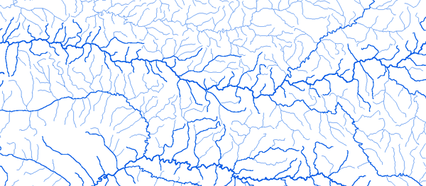
Bassin du Mono
|
||||
|
|
||||
|
RAPPEL : Le téléchargement de données est libre moyennant un enregistrement sur ce site et l'édition et le renvoi de la déclaration de l'utilisateur signée.
|
||||
|
|
||||
|
Le Mono |
 |
|||
|
Agome Seva 01°40'01"E 06°34'01"N |
 |
 |
 |
 |
|
Amou Oblo 01°50'00"E 07°24'00"N |
|
|
|
|
|
Anie Gare 01°11'01"E 07°45'01"N |
|
|
|
|
|
Blitta Gare 1 00°58'01"E 08°20'01" |
|
|
|
|
|
Correkope 01°18'01"E 07°48'01"N |
|
|
|
|
|
Dotaikope 01°16'01"E 07°49'01"N |
|
|
|
|
|
Ebeva 01°05'01"E 07°32'01"N |
|
|
|
|
|
Glei 01°10'01"E 07°20'01"N |
|
|
|
|
|
Kpondave 01°47'01"E 06°22'01"N |
|
|
|
|
|
Ngamboto 1 01°26'01"E 07°26'01"N |
|
|
|
|
|
Sirka 01°22'01"E 07°55'01"N |
|
|
|
|
|
Tetetou 01°32'01"E 07°01'01"N |
|
|
|
|
|
Wahala (CHRA) 01°10'01"E 07°10'01"N |
|
|
|
|
|
|
||||