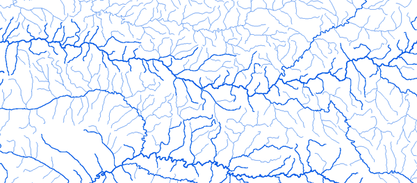
Bassin du Niger

RAPPEL : Le téléchargement de données est libre moyennant un enregistrement sur ce site et l'édition et le renvoi de la déclaration de l'utilisateur signée.

Le Niger

Hydrographic network

Aka 4°14'00"W 15°24'01"N

Outline
Geology
Holdridge Vegetation
WaterHoldingCapacity

Alcongui 00°36'01"E 14°45'01"N

Outline
Geology
Holdridge Vegetation
WaterHoldingCapacity

Ansongo 00°29'91"E 15°39'61"N

Outline
Geology
Holdridge Vegetation
WaterHoldingCapacity

Banankoro 8°40'00"W 11°41'01"N

Outline
Geology
Holdridge Vegetation
WaterHoldingCapacity

Baranama 8°45'30"W 10°07'30"N

Outline
Geology
Holdridge Vegetation
WaterHoldingCapacity

Baro 9°42'00"W 10°37'01"N

Outline
Geology
Holdridge Vegetation
WaterHoldingCapacity

Barou 02°44'57"E 12°21'11"N

Outline
Geology
Holdridge Vegetation
WaterHoldingCapacity

Beneny Kegny 4°52'00"W 13°22'01"N

Outline
Geology
Holdridge Vegetation
WaterHoldingCapacity

Bilanga 0°02'00"W 12°38'01"N

Outline
Geology
Holdridge Vegetation
WaterHoldingCapacity

Bougouni 7°24'00"W 11°24'01"N

Outline
Geology
Holdridge Vegetation
WaterHoldingCapacity

Buffle Noir 13°50'01"E 08°07'01"N

Outline
Geology
Holdridge Vegetation
WaterHoldingCapacity

Campement W 02°24'15"E 12°28'16"N

Outline
Geology
Holdridge Vegetation
WaterHoldingCapacity

Cossi 13°52'01"E 09°37'01"N

Outline
Geology
Holdridge Vegetation
WaterHoldingCapacity

Couberi 03°20'01"E 11°45'01"N

Outline
Geology
Holdridge Vegetation
WaterHoldingCapacity

Dialakoro 8°54'00"W 11°27'01"N

Outline
Geology
Holdridge Vegetation
WaterHoldingCapacity

Dioila 6°48'00"W 12°31'01"N

Outline
Geology
Holdridge Vegetation
WaterHoldingCapacity

Diongore 02°14'53"E 12°55'48"N

Outline
Geology
Holdridge Vegetation
WaterHoldingCapacity

Dire 3°23'00"W 16°16'01"N

Outline
Geology
Holdridge Vegetation
WaterHoldingCapacity

Djirila 7°36'05"W 10°07'10"N

Outline
Geology
Holdridge Vegetation
WaterHoldingCapacity

Dolbel 00°14'50"E 14°37'46"N

Outline
Geology
Holdridge Vegetation
WaterHoldingCapacity

Douna 5°54'00"W 13°13'01"N

Outline
Geology
Holdridge Vegetation
WaterHoldingCapacity

Faranah 10°45'00"W 10°02'01"N

Outline
Geology
Holdridge Vegetation
WaterHoldingCapacity

Garbe Kourou 01°37'01"E 13°44'01"N

Outline
Geology
Holdridge Vegetation
WaterHoldingCapacity

Garoua 13°23'01"E 09°18'01"N

Outline
Geology
Holdridge Vegetation
WaterHoldingCapacity

Gouala 8°14'00"W 11°58'01"N

Outline
Geology
Holdridge Vegetation
WaterHoldingCapacity

GounouGaya 15°30'01"E 09°41'30"N

Outline
Geology
Holdridge Vegetation
WaterHoldingCapacity

Guinguerini 6°36'00"W 09°32'01"N

Outline
Geology
Holdridge Vegetation
WaterHoldingCapacity

Iradougou 4°05'00"W 09°42'25"N

Outline
Geology
Holdridge Vegetation
WaterHoldingCapacity

Kakassi 01°26'01"E 13°51'01"N

Outline
Geology
Holdridge Vegetation
WaterHoldingCapacity

Kankan 9°18'00"W 10°23'01"N

Outline
Geology
Holdridge Vegetation
WaterHoldingCapacity

Ke Macina 5°22'00"W 13°57'01"N

Outline
Geology
Holdridge Vegetation
WaterHoldingCapacity

Kerouane 9°02'00"W 09°16'01"N

Outline
Geology
Holdridge Vegetation
WaterHoldingCapacity

Kirango Aval 6°03'00"W 13°42'01"N

Outline
Geology
Holdridge Vegetation
WaterHoldingCapacity

Kissidougou 10°01'00"W 09°15'01"N

Outline
Geology
Holdridge Vegetation
WaterHoldingCapacity

Kompongou 02°12'01"E 11°02'01"N

Outline
Geology
Holdridge Vegetation
WaterHoldingCapacity

Korioume 3°02'00"W 16°40'01"N

Outline
Geology
Holdridge Vegetation
WaterHoldingCapacity

Koriziena 00°01'52"E 14°22'53"N

Outline
Geology
Holdridge Vegetation
WaterHoldingCapacity

Koulikoro 7°33'00"W 12°52'01"N

Outline
Geology
Holdridge Vegetation
WaterHoldingCapacity

Kouoro 5°41'00"W 12°01'01"N

Outline
Geology
Holdridge Vegetation
WaterHoldingCapacity

Kouroussa 9°52'00"W 10°39'01"N

Outline
Geology
Holdridge Vegetation
WaterHoldingCapacity

Koutakroukrou Rte Kandi Segbana 03°04'01"E 11°04'01"N

Outline
Geology
Holdridge Vegetation
WaterHoldingCapacity

Kouto Aval 6°24'52"W 09°53'41"N

Outline
Geology
Holdridge Vegetation
WaterHoldingCapacity

Lokodja 06°46'01"E 07°48'01"N

Outline
Geology
Holdridge Vegetation
WaterHoldingCapacity

Makurdi 08°32'01"E 07°45'01"N

Outline
Geology
Holdridge Vegetation
WaterHoldingCapacity

Malanville 03°23'01"E 11°52'01"N

Outline
Geology
Holdridge Vegetation
WaterHoldingCapacity

Mandiana 8°41'00"W 10°37'01"N

Outline
Geology
Holdridge Vegetation
WaterHoldingCapacity

M'Bourao 14°47'01"E 09°50'01"N

Outline
Geology
Holdridge Vegetation
WaterHoldingCapacity

Mopti 4°12'00"W 14°30'01"N

Outline
Geology
Holdridge Vegetation
WaterHoldingCapacity

Niamey 02°11'41"E 13°23'15"N

Outline
Geology
Holdridge Vegetation
WaterHoldingCapacity

Onitsha 06°46'01"E 06°11'01"N

Outline
Geology
Holdridge Vegetation
WaterHoldingCapacity

Ouaran 9°24'00"W 11°22'01"N

Outline
Geology
Holdridge Vegetation
WaterHoldingCapacity

Pankourou 6°34'00"W 11°25'01"N

Outline
Geology
Holdridge Vegetation
WaterHoldingCapacity

Patalao 15°16'01"E 09°51'01"N

Outline
Geology
Holdridge Vegetation
WaterHoldingCapacity

Ponondougou 6°21'35"W 09°31'20"N

Outline
Geology
Holdridge Vegetation
WaterHoldingCapacity

Pont Carol 15°30'01"E 09°17'01"N

Outline
Geology
Holdridge Vegetation
WaterHoldingCapacity

Riao 13°41'01"E 09°03'01"N

Outline
Geology
Holdridge Vegetation
WaterHoldingCapacity

Rte Kandi Banikoara
02°39'01"E 11°14'01"N

Outline
Geology
Holdridge Vegetation
WaterHoldingCapacity

Rte Kandi Segbana 03°15'01"E 10°59'01"N

Outline
Geology
Holdridge Vegetation
WaterHoldingCapacity

Samatiguila 7°33'15"W 09°49'81"N

Outline
Geology
Holdridge Vegetation
WaterHoldingCapacity

Selingue 8°10'00"W 11°35'01"N

Outline
Geology
Holdridge Vegetation
WaterHoldingCapacity

Sofara 4°15'00"W 14°01'01"N

Outline
Geology
Holdridge Vegetation
WaterHoldingCapacity

Tamou 02°11'01"E 12°46'01"N

Outline
Geology
Holdridge Vegetation
WaterHoldingCapacity

Tiguibery (Siguiri) 9°10'00"W 11°26'01"N

Outline
Geology
Holdridge Vegetation
WaterHoldingCapacity

Tilembeya 5°00'00"W 14°09'01"N

Outline
Geology
Holdridge Vegetation
WaterHoldingCapacity

Tinkisso 10°35'30"W 11°14'40"N

Outline
Geology
Holdridge Vegetation
WaterHoldingCapacity

Tossaye 0°35'00"W 16°56'01"N

Outline
Geology
Holdridge Vegetation
WaterHoldingCapacity

Ziemougoula 7°25'54"W 09°55'20"N

Outline
Geology
Holdridge Vegetation
WaterHoldingCapacity
Fermer cette page Imprimer cette page
© UMR HydroSciences Montpellier